Aug. 03, 2026
Date: May 27, 2020; Elevation announced on December 8: 8848.86 meters. Key Content:
· China completed the Mount Everest height measurement entirely using domestically produced surveying equipment for the first time, ending its reliance on imports (Leica/Tempo). (People's Daily Online)
· Huace Navigation's P5 Beidou GNSS receiver was the only domestically produced Beidou equipment to reach the summit, withstanding extreme environments including -45℃, 30kPa low pressure, and oxygen deficiency. (The Paper)
· Accuracy: Horizontal accuracy 2.5mm, vertical accuracy 3.5mm/km, primarily Beidou III, compatible with GPS/GLONASS/Galileo (People's Republic of China)...
· Significance: Domestically produced surveying equipment has reached world-class levels, breaking the foreign monopoly.
Authoritative Sources: Ministry of Natural Resources Official Website, People's Daily Online, The Paper... News Footage of Mount Everest Summit Team Operating Huace Equipment 1 | 2020 Mount Everest Height Measurement: Huace Navigation's Domestically Produced Beidou GNSS Receiver Reaches the World's Summit for the First Time (National Milestone)
Release Date: May 27, 2020 (Summit); December 8 (New Height Announced: 8848.86 meters) Authoritative Sources: Ministry of Natural Resources, People's Daily Online, The Paper, Shanghai Science and Technology Key Events (Details): In 2020, China launched its third Mount Everest height measurement, using domestically produced surveying equipment for the first time, completely ending its reliance on imported instruments from Leica and Trimble. The P5 Beidou GNSS receiver developed by Shanghai Huace Navigation became the only domestically produced high-precision positioning device to successfully reach the summit, marking the first time Chinese Beidou equipment has reached the world's highest point.
Technical Background (Why Domestic Production is Essential, Why is it Difficult?)
· Summit Environment: -45℃ extreme cold, air pressure only 30kPa (1/3 of sea level), oxygen deficiency, gale-force winds (level 8), strong ultraviolet radiation...
· Equipment Requirements: First summit attempt, successful completion on the first try, 12 hours of continuous operation, millimeter-level precision, anti-accidental touch, ultralight.
· Historical Comparison: In 1975, optical instruments were used; in 2005, imported GPS equipment was used; in 2020, 100% domestically produced equipment + BeiDou-based...
HuaCe Equipment Parameters (Public and Authoritative)
· Model: HuaCe P5 GNSS Receiver (Primarily for BeiDou-3)
· Accuracy: Horizontal 2.5mm, Vertical 3.5mm/km (millimeter-level)
· Environment: Normal operation at -45℃, IP68 waterproof and dustproof, anti-misoperation design
· Battery Life: 12 hours of continuous operation in low-temperature environments (Shangguan News)
· Weight: Light as 1.2kg, suitable for summiting
On-site Operation (Actual Scene, No Instrument Close-ups)
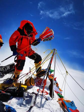
· At 11:00 AM on May 27th, eight summit team members erected a target at the 8848.86-meter summit. The HuaCe equipment was fixed to the top of the target, receiving real-time signals from BeiDou-3 + GPS + GLONASS + Galileo four-satellite systems.
· The team members completed the equipment setup, startup, and data acquisition in -40℃ and oxygen-deficient conditions, a process that took approximately 40 minutes.
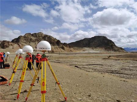
· Seven CTI BeiDou reference stations were deployed at Mount Everest Base Camp, performing real-time differential calculations with equipment at the summit to ensure absolute elevation accuracy.
Achievements and Significance (National Level)
✅ The latest elevation of Mount Everest was measured at 8848.86 meters, jointly released by China and Nepal and globally recognized.
✅ Domestically produced surveying equipment reached world-class levels for the first time, breaking the monopoly of Europe and the United States.
✅ For the first time in a world-class project after the completion of the BeiDou-3 global network, it fully replaced GPS.
✅ CTI became one of the very few GNSS manufacturers in the world capable of stable operation in the extremely cold and low-pressure environment at 8800 meters.
• Mount Everest Base Camp GNSS Reference Station (Huace White Antenna)